Cincinnati / Northern Kentucky International Airport (CVG)
Orientation and Maps
(Cincinnati, Ohio (OH), USA)
Based around the Ohio River, Cincinnati is an attractive city of sophistication. Full of waterfront attractions, Cincinnati is famous for its high concentration of Art Deco buildings and stylish structures. The city is also known for its large paddle boats and traditional cuisine, with a host of restaurants in the Mount Adams area, along the banks of the river, and in the Clifton district, close to the University of Cincinnati.
Cincinnati is home to two airports, both of which are located nearby. The Northern Kentucky International Airport (CVG) is a thriving transport hub and lies on the southwestern side of the city, while the smaller Municipal Lunken Airport (LUK) stands to the southeast, next to the US-50 highway. In addition to these airports, Cincinnati's Amtrak train station is located along the Western Avenue, at the popular Cincinnati Museum Center.
Public transport in the city includes local commuter buses, which are operated by Metro. The buses connect with the Transit Authority of Northern Kentucky and provide a very inexpensive way to travel around the city. Those looking for a comprehensive map of Cincinnati should head to the visitors center, along Walnut Street.
Cincinnati / Northern Kentucky International Airport (CVG) Maps: Important City Districts
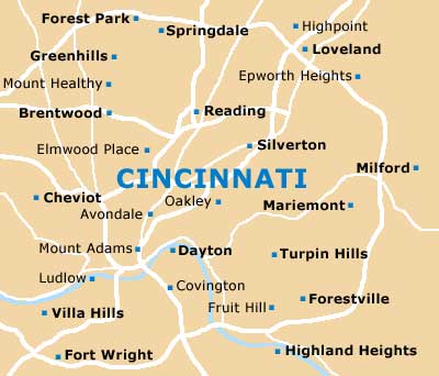
The streets and roads in Cincinnati's downtown district are laid out in a simple gridwork pattern, being centered around Fountain Square. An important thoroughfare, Vine Street heads in an east-west direction and divides much of this area. Both easterly and westerly streets in the downtown district are numbered logically, while those heading north and south each have individual names.
Notable landmarks in the downtown district include the late 19th-century Rosbling Suspension Bridge and the imposing 'Spirit of the Waters' fountain, which can be found in the center of Fountain Square.
USA Map
Ohio Map

Cincinnati Map